FREESE-NOTIS
UNITED STATES WEATHER AND CROP COMMENTS
4:00 AM, Thursday, May 09, 2024
FORECAST HIGHLIGHTS
-
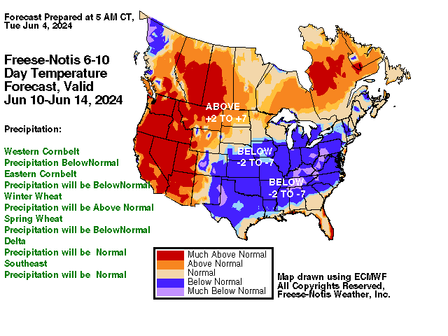
MIDWEST - For the 1-5 day outlook May 9-May 14, corn belt temperatures will average near 62.7 F which is -.3F from normal. Rainfall will average 0.63". Approximately 80% of the area will receive a 0.25" or more. This compares to the earlier estimate today of 61%. For the 6-10 day outlook, May 14-May 18, the western corn belt temperatures will be ABOVE NORMAL. Rainfall will be ABOVE NORMAL. Eastern corn belt temperatures will be ABOVE NORMAL. Rainfall will be ABOVE NORMAL.
NORTHEAST - For the 1-5 day outlook May 9-May 14, megalopolis area temperatures will average near 55.9 F which is -6.3 F from normal. Rainfall will average 0.60". Approximately 100% of the area will receive a 0.25" or more. This compares to the earlier estimate today of 100%.For the 6-10 day outlook, May 14-May 18, The Megalopolis temperatures will be ABOVE NORMAL. Rainfall will be ABOVE NORMAL.
DELTA/SOUTHEAST - For the 1-5 day outlook May 9-May 14, delta area temperatures will average near 69.7 F which is -1.8 F from normal. Rainfall will average 1.09". Approximately 100% of the area will receive a 0.25" or more. This compares to the earlier estimate today of 100%.For the 6-10 day outlook, May 14-May 18, the Delta region temperatures will be NORMAL. Rainfall will be NORMAL. The southeast region temperatures will be ABOVE NORMAL. Rainfall will be ABOVE NORMAL.
NORTHERN 1/2 PLAINS - For the 1-5 day outlook May 9-May 14, spring wheat temperatures will average near 60.4 F which is 3.3 F from normal. Rainfall will average 0.13". Approximately 22% of the area will receive a 0.25" or more. This compares to the earlier estimate today of 4%.For the 6-10 day outlook, May 14-May 18, the spring wheat temperatures will be ABOVE NORMAL. Rainfall will be ABOVE NORMAL.
SOUTHERN 1/2 PLAINS - For the 1-5 day outlook May 9-May 14, winter wheat temperatures will average near 64.1 F which is -.3 F from normal. Rainfall will average 0.70". Approximately 89% of the area will receive a 0.25" or more.. This compares to the earlier estimate today of 38%.For the 6-10 day outlook, May 14-May 18, the winter wheat temperatures will be ABOVE NORMAL. Rainfall will be ABOVE NORMAL.
CROP/LIVESTOCK/ENERGY IMPACTS
-
MIDWEST - Central Iowa reports Field conditions are normal Prospects above normal some fields to wet . Additonal precipitation needed to end the drought, 4.39".Southwest Iowa reports Prospects above normal some fields to wet. . Additonal precipitation needed to end the drought, 5.81". Warmer than normal temperatures will reduce livestock feed needs.
DELTA/SOUTHEAST - Northeast Arkansas reports moisture is adequate for present needs. mild to moderate drought Field conditions are drying Livestock feed needs will be normal for this time of the year.
NORTHERN 1/2 PLAINS - Northeast North Dakota reports moisture is adequate for present needs. Field conditions are normal Colder than normal temperatures will increase livestock feed needs.
SOUTHERN 1/2 PLAINS - South Central Kansas reports moisture is adequate for present needs Field conditions are normal, . Additonal precipitation needed to end the drought, 4.14".West Central Kansas reports Prospects improved but rain still needed severe drought, . Additonal precipitation needed to end the drought, 4.7".Southwestern Kansas reports Prospects improved but rain still needed severe drought, . Additonal precipitation needed to end the drought, 2.85". Warmer than normal temperatures will reduce livestock feed needs.
- PAST WEATHER/SHORT-RANGE FORECAST
MIDWESTERN U.S. (NE to OH and central MN to southern IL)
-
Yesterday's temperatures across the western corn belt averaged 67.9 F about 6.5 F from normal. Rainfall averaged 0.16". Approximately 25% of the area received a 0.25" or more. Yesterday's temperatures across the eastern corn belt averaged 69.4 F about 7.4 F from normal. Rainfall averaged 0.50". Approximately 49% of the area will received a 0.25" or more.
For the 1-5 day outlook May 9-May 14, corn belt temperatures will average near 62.7 F which is -.3F from normal. Rainfall will average 0.63". Approximately 80% of the area will receive a 0.25" or more. This compares to the earlier estimate today of 61%.
 SOUTHEASTERN U.S. (Delta east to Carolinas)
-
For the 1-5 day outlook May 9-May 14, delta area temperatures will average near 69.7 F which is -1.8 F from normal. Rainfall will average 1.09". Approximately 100% of the area will receive a 0.25" or more. This compares to the earlier estimate today of 100%.
For the 6-10 day outlook, May 14-May 18, the Delta region temperatures will be NORMAL. Rainfall will be NORMAL. The southeast region temperatures will be ABOVE NORMAL. Rainfall will be ABOVE NORMAL.
NORTHERN PLAINS (ND to northern NE, eastern MT, eastern WY, northwest MN)
-
Yesterday's temperatures across the spring wheat belt averaged 59.7 F about 4.4 F from normal. Rainfall averaged 0.10". Approximately 17% of the area received a 0.25" or more.
For the 1-5 day outlook May 9-May 14, spring wheat temperatures will average near 60.4 F which is 3.3 F from normal. Rainfall will average 0.13". Approximately 22% of the area will receive a 0.25" or more. This compares to the earlier estimate today of 4%.
SOUTHERN PLAINS (southern NE to northern TX)
-
Yesterday's temperatures across the winter wheat belt averaged 62.1 F about -.7 F from normal. Rainfall averaged 1.61". Approximately 3% of the area received a 0.25" or more.
For the 1-5 day outlook May 9-May 14, winter wheat temperatures will average near 64.1 F which is -.3 F from normal. Rainfall will average 0.70". Approximately 89% of the area will receive a 0.25" or more.. This compares to the earlier estimate today of 38%.
NORTHEASTERN U.S. MEGALOPOLIS
-
For the 1-5 day outlook May 9-May 14, megalopolis area temperatures will average near 55.9 F which is -6.3 F from normal. Rainfall will average 0.60". Approximately 100% of the area will receive a 0.25" or more. This compares to the earlier estimate today of 100%.
For the 6-10 day outlook, May 14-May 18, The Megalopolis temperatures will be ABOVE NORMAL. Rainfall will be ABOVE NORMAL.
 EXTENDED OUTLOOK & GENERAL OVERVIEW OF U.S. PATTERN
-
For the 6-10 day outlook, May 14-May 18, the western corn belt temperatures will be ABOVE NORMAL. Rainfall will be ABOVE NORMAL. Eastern corn belt temperatures will be ABOVE NORMAL. Rainfall will be ABOVE NORMAL.
-
Copyright 2014
WAYNE ELLIS/METEOROLOGIST
Freese - Notis Weather
Des Moines, IA 50312
United States of America
Tel (515) 282-9310
E-mail
hfreese@weather.net
IM: weathertrader89
Twitter: @freesenotiswx